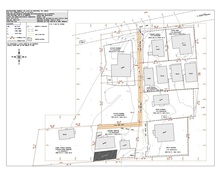
Topographic SurveysTopographic surveys are needed when conducting spatial planning. The topographic survey shows the trees, houses, spot heights, contours and legal boundaries of the site.
|

Precision Setting OutThis can be used where structures (roads, buildings), needs to be precisely placed within or onto a specified area. Buildings are normally set out by the engineering surveyors when the site is very small or where the contractor does not want to use batten boards. The advantage of having your building precisely set out is that it prevents the building or land owner from encroaching onto their neighbours. It also ensures that building dimensions are precise. Service supply lines (electrical and plumbing) within a building can also be precisely set out and mapped so that these services can be easily found in the future.
|
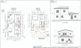
Building Design Services
This is where customized architectural drawings or house designs are drawn/prepared according to the clients requirements.
|
BENEFICIAL INFORMATION

Survey Plans and their uses
Legal uses
Survey plans are needed when transferring land from one party to the next so that areas, location encroachments or no encroachments can be confirmed or determined if unknown. Subsequent to some recent legislation, the age of a plot has to be 15 years or less when transferring property (that is in Barbados). But sometimes if the survey plans are adequate (even when they are older than 15 years) a retracement report or a boundary certificate may be required.
Engineering/Drafting uses
The boundary survey plan allows the architect to design a plan which is capable of fitting onto your property. If the size of the property is known then the design of the structure should be less than the size of the property. The design should also be 40% less of the total land size (this is for residential purposes). Topographic surveys are also undertaken to determine the contours/heights and any other features that are on the land.
Town and Country Development Planning uses
When application are to be processed by/for this department the boundary surveyor's plans are needed so that the officers in the Town and Country Development Planning Office can confirm that proposed structures are within the reserves (drainage and road reserves) and limits of the property. For this department a copy of the surveyor's plan(no age limit) is generally adequate documentation to assist in the assessment of the application. However for those properties along/abutting the coast line will require a high water mark survey which has to be conducted in a time frame less than 2 years.
Some benefits of knowing where your boundary markers are located
Knowing your boundary limits, prevents you from venturing onto your neighbour's property (especially when installing fences, guard walls, planting garden beds or building structures). Knowledge of where the boundaries are may also prevent the obstruction of easements (such as rights of passage) and may sometimes prevent unnecessary arguments (boundary disputes) among neighbouring land owners.